Weird borders- they’re basically scribbles
You have probably heard of the
term “borders”, the lines that separates two countries. Sometimes they are like a scribble that a 2-year-old
drew. Sometimes borders extend from their country like a pan’s handle (maybe the
ones who made their border wanted to fry something in their country). Lets look at some weird borders.
Afghanistan
First,
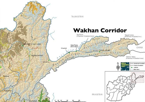
we have our neighbour, Afghanistan where we find the Wakhan corridor
which makes no sense. It's a 350 kilometres and a width of 13 to 65 kilometres.
However, is reason lies in the past. In the 19th century both the
British and Russians wanted to expand their territory into the Wakhan corridor region
and to solve a dispute between Russia and UK, they both used Afghanistan as a
buffer state in-between them but Afghanistan’s border didn't exactly match up with
the Russian British border so they extended Afghanistan 350 kilometres east to
fill the gap and now it remains, but separates Pakistan and Tajikistan.
 |
Namibia
Next,
we move to Africa where we find Namibia in which the Caprivi strip is
located. This strip shape extends like a pan handle from Namibia. In the 19th
century, Germany used to control Namibia and Germany wanted access to the
Indian ocean. So, she sold the island of Zanzibar near Tanzania and bought a long
strip of land (called as Caprivi Strip named after German Chancellor of that
time, Mr. Leo Van Caprivi) from the British, which gives Germany access to the
Zambezi river which connected to the Indian ocean.
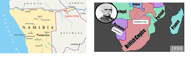
However,
this purchase became useless as in the middle of the Zambezi river is Victoria
falls, the largest waterfall in the world, which does not allow any ship to
reach the Indian ocean in one piece!!!
Spain
When
you think of Spain, you imagine it to be in mainland Europe. It is not entirely
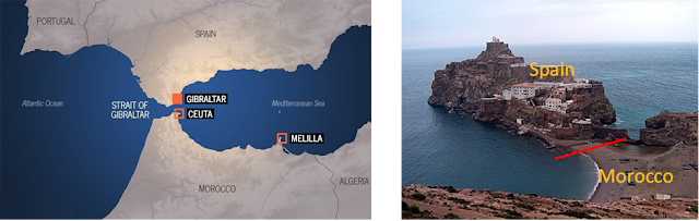
true because of the tiny pieces of Spain in Africa. Let me explain. You see
Spain used to control posts of Morocco and western Sahara. Spain gave Morocco
independence in 1900s but still held on to few tiny pieces called as plazas
de soberanía. These include the cities of Ceuta and Malila and a few scattered islands.
The
most interesting of it is small peninsula with a big name Peñón de Vélez
de la Gomera. This place has which has the shortest border in the world,
where Spain borders Morocco which is only 74 meters long
Sweden & Finland
The
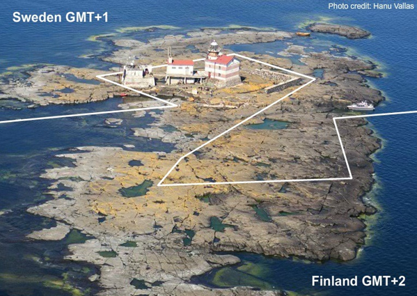
island of Märket lies in between Sweden and Finland. You see in the 17th
century Sweden and Russia (which used to control Finland) divided the island in
half. About 50 years later when Finland
was independent, it built a lighthouse on a hill which was one the Swedish
side. After knowing about this, Sweden was furious with Finland. Finally, after
a 100 years, the governments of both countries signed an agreement to change
the border the zigzag pattern we have today so that either side did not lose
land
As
you see the borders of the world may cause problems that can only be solved by
guru of borders: Master Gurubaran himself

Great Guru
ReplyDeleteThanks periyappa - Guru
ReplyDeleteSuperb to read about these borders! Especially about the Caprivi strip and the reason the purchase eventually made no sense.
ReplyDeleteThanks uncle - Gurubaran
DeleteInteresting read. Some of the logic borders lunacy (pun intended). My favourite is the Spain Morocco border, just 74 meters long, almost like neighbouring houses. Funny to imagine how soldiers would line up across the border in case of a war between the two countries.
ReplyDelete